
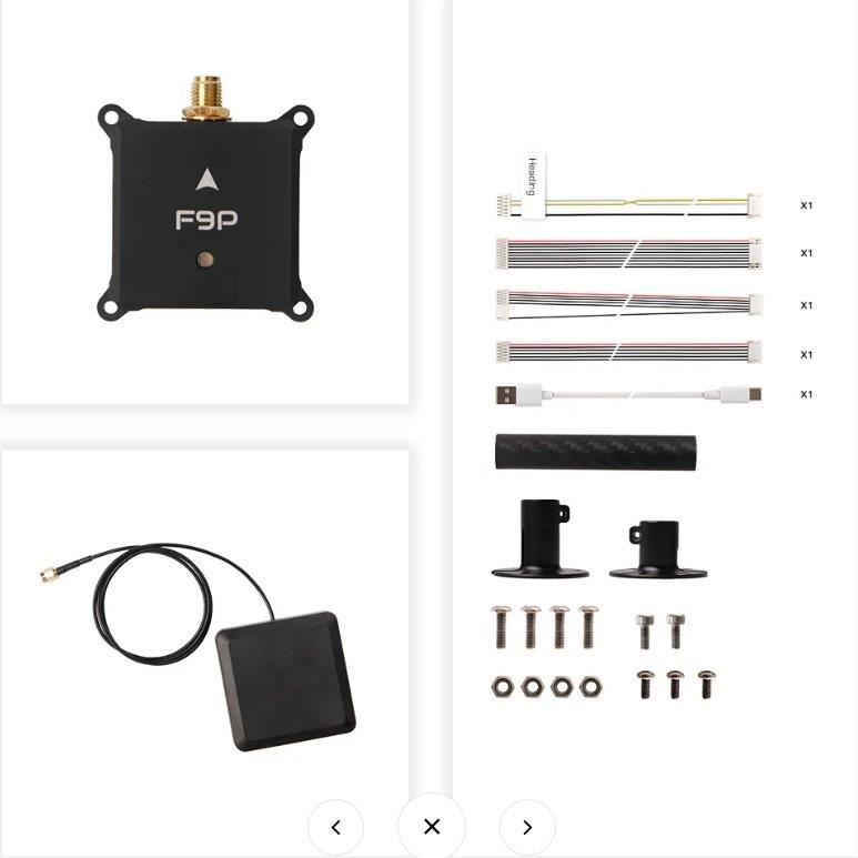
Holybro H-RTK NEO-F9P w/ Vertical Array Patch Antenna, 80cm
4 571 SEK
- Säkra kortbetalningar
- Fri frakt på ordrar över 2500kr
Beskrivning
Art.nr: 12068
Overview
The H-RTK NEO-F9P GPS integrates the advanced u-blox NEO-F9P GNSS receiver, high-precision RM3100 compass, and a tri-color LED indicator. This high-precision system delivers multi-band RTK capabilities with rapid convergence times, reliable performance, and fast update rates, which is ideal for highly dynamic, high-volume applications requiring centimeter-level accuracy. Multiple antenna options are available to suit diverse use cases.
Supporting concurrent reception of GPS (L1 & L5), GLONASS, Galileo, BeiDou, and QZSS signals, it offers flexible connectivity in both UART and DroneCAN options. The DroneCAN version includes an MCU, IMU, and barometer, enabling robust communication and seamless integration for advanced UAV systems.
The high-precision PNI RM3100 compass ensures accurate orientation and stability with exceptional reliability, making it perfect for demanding UAV applications. It features high resolution, low power consumption, strong noise immunity, a broad dynamic range, and high sampling rates. Measurements are stable across temperatures and inherently free from offset drift.
Features
Advanced GNSS Receiver: High precision u-blox NEO-F9P GNSS receiver with reliable and stable centimeter-level positioning
Integrated RM3100 Compass: Accurate and stable orientation data
Rapid RTK Convergence: Advanced multi-frequency DGNSS algorithms enable quick RTK Fix
High-Gain Antenna: Enhanced signal reception across GNSS frequencies
Advanced Filtering & Amplification: Hybrid Coupler, SAW filter, and LNA architecture deliver exceptional signal strength and effective interference rejection
Versatile Installation: Multiple antenna options offer flexibility for various situations
DroneCAN Option: Offers MCU, IMU, barometer, and robust communication for advanced UAV systems
Product Model:
H-RTK NEO-F9P w/ Helical Antenna / H-RTK NEO-F9P w/ Vertical Array Patch Antenna / H-RTK NEO-F9P w/ Base Station Antenna
Recommended Application:
Rover Station (UAV, Marine, Land Vehicle, etc) / Rover Station (UAV, Marine, Land Vehicle, etc)
Base Station / Rover Station (Marine, Land Vehicle, etc) Base Station
GNSS Receiver: u-blox NEO-F9P / u-blox NEO-F9P / u-blox NEO-F9P
Processor: STM32G473 (Available in DroneCAN Version Only) / N/A
IMU & Barometer: ICM42688 & ICP20100 (Available in DroneCAN Version Only) / N/A
Antenna:
Helical Antenna / High Precision Vertical Array Patch Antenna / High-Gain Ceramic Antenna
Antennas Peak Gain:
L1: 2dBi / L1: 3.5dBi / L1: 5.5dBi
L5: 2dBi / L5: 3.5dBi / L5: 4dBi
Antennas LNA Gain: 33 ± 2dB / 33 ± 2dB / 40 ± 2dB
Magnetometer: High Precision PNI RM3100
GNSS: BeiDou, Galileo, GLONASS, GPS / QZSS
GNSS Band: B1I, B2I, E1B/C, E5b, L1C/A, L1OF, L2C, L2OF
Number of Concurrent GNSS: 4
Dynamic Heading Accuracy: 0.3 degrees
Horizontal Positioning Accuracy
PVT: 1.5 m CEP
SBAS: 1.0 m CEP
RTK: 0.01 m +1 ppm CEP
Vertical Positioning Accuracy
PVT: 2.0 m R50
SBAS: 1.5 m R50
RTK: 0.01 m +1 ppm R51
Communication Protocol: UART or DroneCAN 1 Mbit/s
GNSS Protocol
NMEA
UBX binary
RTCM 3.3
SPARTN 2.0.1
Time-To-First Fix
Hot Start: 3 s
Aided Starts: 4 s
Cold Starts: 27 s
Navigation Update Rate
GPS+GLO+GAL+BDS:
RTK: 7 Hz Max
PVT: 7 Hz Max
RAW: 10 Hz
Anti-Spoofing: Advanced anti-spoofing algorithms
Operational Limits:
Dynamics: ≤ 4 g
Altitude: 80,000 m
Velocity: 500 m/s
Antenna Connection Type
Board: SMA female
Antenna: SMA male
Working Voltage 4.75 V ~ 5.25 V
Operating Temperature -25℃ to 85℃
Current Consumption ~250 mA
Antenna Cable Length
40 cm (default) / 40 or 80 cm / 500 cm
Dimensions
Module: 43.1×44.1×22 mm / Module: 43.1×44.1×22 mm / Module: 43.1×44.1×22 mm
Antenna Diameter: 27.5 mm / Antenna: 75×75×26 mm / Antenna Diameter: 152 mm
Antenna Height: 59 mm / - / Antenna Height: 62.2 mm
Weight
Module: 40 g / Module: 40 g / Module: 40 g
Antenna: 18 g / Antenna: 168 g / Antenna: 343 g
SKU12068 12070 Included:
1x NEO F9P Helical-UART
1x High-Precision Vertical Array Patch Antenna(Cable 80cm/Cable 40cm)
1x Fixed Carbon Fiber Antenna mount
The H-RTK NEO-F9P GPS integrates the advanced u-blox NEO-F9P GNSS receiver, high-precision RM3100 compass, and a tri-color LED indicator. This high-precision system delivers multi-band RTK capabilities with rapid convergence times, reliable performance, and fast update rates, which is ideal for highly dynamic, high-volume applications requiring centimeter-level accuracy. Multiple antenna options are available to suit diverse use cases.
Supporting concurrent reception of GPS (L1 & L5), GLONASS, Galileo, BeiDou, and QZSS signals, it offers flexible connectivity in both UART and DroneCAN options. The DroneCAN version includes an MCU, IMU, and barometer, enabling robust communication and seamless integration for advanced UAV systems.
The high-precision PNI RM3100 compass ensures accurate orientation and stability with exceptional reliability, making it perfect for demanding UAV applications. It features high resolution, low power consumption, strong noise immunity, a broad dynamic range, and high sampling rates. Measurements are stable across temperatures and inherently free from offset drift.
Features
Advanced GNSS Receiver: High precision u-blox NEO-F9P GNSS receiver with reliable and stable centimeter-level positioning
Integrated RM3100 Compass: Accurate and stable orientation data
Rapid RTK Convergence: Advanced multi-frequency DGNSS algorithms enable quick RTK Fix
High-Gain Antenna: Enhanced signal reception across GNSS frequencies
Advanced Filtering & Amplification: Hybrid Coupler, SAW filter, and LNA architecture deliver exceptional signal strength and effective interference rejection
Versatile Installation: Multiple antenna options offer flexibility for various situations
DroneCAN Option: Offers MCU, IMU, barometer, and robust communication for advanced UAV systems
Product Model:
H-RTK NEO-F9P w/ Helical Antenna / H-RTK NEO-F9P w/ Vertical Array Patch Antenna / H-RTK NEO-F9P w/ Base Station Antenna
Recommended Application:
Rover Station (UAV, Marine, Land Vehicle, etc) / Rover Station (UAV, Marine, Land Vehicle, etc)
Base Station / Rover Station (Marine, Land Vehicle, etc) Base Station
GNSS Receiver: u-blox NEO-F9P / u-blox NEO-F9P / u-blox NEO-F9P
Processor: STM32G473 (Available in DroneCAN Version Only) / N/A
IMU & Barometer: ICM42688 & ICP20100 (Available in DroneCAN Version Only) / N/A
Antenna:
Helical Antenna / High Precision Vertical Array Patch Antenna / High-Gain Ceramic Antenna
Antennas Peak Gain:
L1: 2dBi / L1: 3.5dBi / L1: 5.5dBi
L5: 2dBi / L5: 3.5dBi / L5: 4dBi
Antennas LNA Gain: 33 ± 2dB / 33 ± 2dB / 40 ± 2dB
Magnetometer: High Precision PNI RM3100
GNSS: BeiDou, Galileo, GLONASS, GPS / QZSS
GNSS Band: B1I, B2I, E1B/C, E5b, L1C/A, L1OF, L2C, L2OF
Number of Concurrent GNSS: 4
Dynamic Heading Accuracy: 0.3 degrees
Horizontal Positioning Accuracy
PVT: 1.5 m CEP
SBAS: 1.0 m CEP
RTK: 0.01 m +1 ppm CEP
Vertical Positioning Accuracy
PVT: 2.0 m R50
SBAS: 1.5 m R50
RTK: 0.01 m +1 ppm R51
Communication Protocol: UART or DroneCAN 1 Mbit/s
GNSS Protocol
NMEA
UBX binary
RTCM 3.3
SPARTN 2.0.1
Time-To-First Fix
Hot Start: 3 s
Aided Starts: 4 s
Cold Starts: 27 s
Navigation Update Rate
GPS+GLO+GAL+BDS:
RTK: 7 Hz Max
PVT: 7 Hz Max
RAW: 10 Hz
Anti-Spoofing: Advanced anti-spoofing algorithms
Operational Limits:
Dynamics: ≤ 4 g
Altitude: 80,000 m
Velocity: 500 m/s
Antenna Connection Type
Board: SMA female
Antenna: SMA male
Working Voltage 4.75 V ~ 5.25 V
Operating Temperature -25℃ to 85℃
Current Consumption ~250 mA
Antenna Cable Length
40 cm (default) / 40 or 80 cm / 500 cm
Dimensions
Module: 43.1×44.1×22 mm / Module: 43.1×44.1×22 mm / Module: 43.1×44.1×22 mm
Antenna Diameter: 27.5 mm / Antenna: 75×75×26 mm / Antenna Diameter: 152 mm
Antenna Height: 59 mm / - / Antenna Height: 62.2 mm
Weight
Module: 40 g / Module: 40 g / Module: 40 g
Antenna: 18 g / Antenna: 168 g / Antenna: 343 g
SKU12068 12070 Included:
1x NEO F9P Helical-UART
1x High-Precision Vertical Array Patch Antenna(Cable 80cm/Cable 40cm)
1x Fixed Carbon Fiber Antenna mount